What does your day look like when a blue‑green river is just down the street? In Stevensville, the Bitterroot shapes your routine, from quick trail walks to casting after dinner. If you are considering a move near the water, you want a clear picture of daily access, seasonal rhythms, safety, and what to check before you buy. This guide gives you practical, local context so you can choose confidently. Let’s dive in.
Why Stevensville by the Bitterroot
Stevensville sits along the Bitterroot River with easy access to public lands, parks, and river trails. The town’s parks system includes a River Park that links you to the water and neighborhood green spaces, making short walks and quick outings part of your routine. You can review park locations and amenities through the town’s Parks and Recreation page for the latest maps and updates.
Just north of town, the Lee Metcalf National Wildlife Refuge protects a long stretch of riparian habitat and offers predictable wildlife viewing and low‑impact river access. Trails and observation points make it a reliable place to see birds and seasonal changes on the river corridor.
- Explore the town’s park network and River Park access on the Town of Stevensville Parks & Recreation page: parks and river access
- Learn about habitat, trails, and viewing at Lee Metcalf National Wildlife Refuge
Everyday river access
Living near the Bitterroot means you can step outside for short hits of nature or plan full days on the water. Here is what local use looks like in and around Stevensville.
Fishing made simple
Anglers commonly target rainbow and brown trout in the middle Bitterroot, with native westslope cutthroat present and bull trout managed as a sensitive species. Licensing is straightforward: if you are 12 or older, you generally need a Montana base fishing license, a Conservation License, and the Angler Aquatic Invasive Species Prevention Pass. Fees and rules change, so check current details before you go.
- Review current requirements and purchase options through Montana FWP fishing licenses
- For species and management context on the river, see FWP’s Bitterroot River fisheries supplement
Access in the Stevensville area comes from in‑town trails to the river, state fishing access sites, and designated areas on the refuge. Locals often mention the town’s River Park trail and nearby state sites near the Stevensville bridge and at Bass Creek for shore casting or as put‑ins.
Floating and paddling
The Bitterroot is floated in sections. A commonly referenced middle‑river run passes near Stevensville and downstream toward Florence. Floatability depends on flow. Spring and early summer bring higher, colder water; late summer may be shallower, especially in drier years. Outfitters list put‑ins and takeouts, and shuttle logistics are easy to arrange through local guides.
- For section overviews and seasonal context, browse river float intel for the Missoula area
Trails and close‑to‑home outings
You will find short trail loops, picnic spots, and interpretive history moments around town and just beyond. The River Park path connects to neighborhood streets for quick walks at lunch or after work. Fort Owen State Park, a historic site on the edge of town, adds another easy outing. The refuge rounds it out with maintained paths and observation areas, giving you year‑round river corridor access without a long drive.
Seasons, flows, and safety
Understanding the river’s rhythm helps you plan your year and your outings.
Snowmelt and irrigation season
The Bitterroot is snowmelt‑fed. Flows peak in spring and early summer, then moderate into mid and late summer. Reservoir releases and irrigation withdrawals also shape depth and speed, which in turn affects wading comfort, float timing, and fishing. The state’s river system summaries describe this seasonality and why flows can vary by year.
- Learn how snowmelt and management influence conditions in the Bitterroot River summary
Low water realities
In late summer, certain middle‑valley float sections may be too shallow in dry years. Painted Rocks and other reservoir releases are managed in part to balance irrigation and instream needs, so late‑season availability changes year to year. If floating or fishing is a priority for you, plan to watch flows closely and stay flexible on specific sections.
Safety on the Bitterroot
Cold water and current are real hazards, even on sunny days. During spring runoff, the water is very cold and fast. Always check local conditions, wear a properly fitted life jacket when boating or rafting, and build skills gradually. The National Weather Service offers clear guidance on cold‑water safety.
- Read practical tips in the NWS guide to cold‑water safety
Property types near the river
You have several ways to live the river lifestyle in Stevensville. Each offers a different balance of access, privacy, and diligence needs.
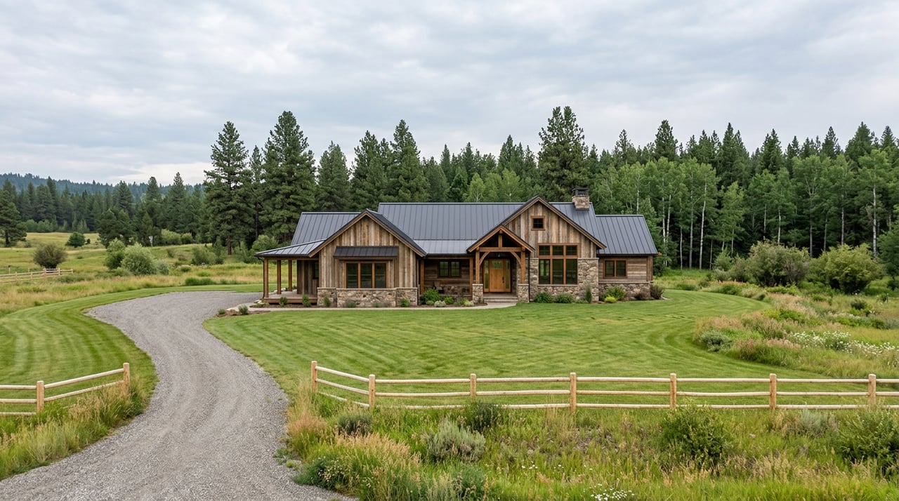
River‑adjacent downtown
If you want walkable access to parks, trails, and historic sites like Fort Owen State Park, look at small lots and cottages near River Park and the core of town. You are not likely to have private frontage, but you can reach the water on foot and enjoy frequent, low‑effort outings.
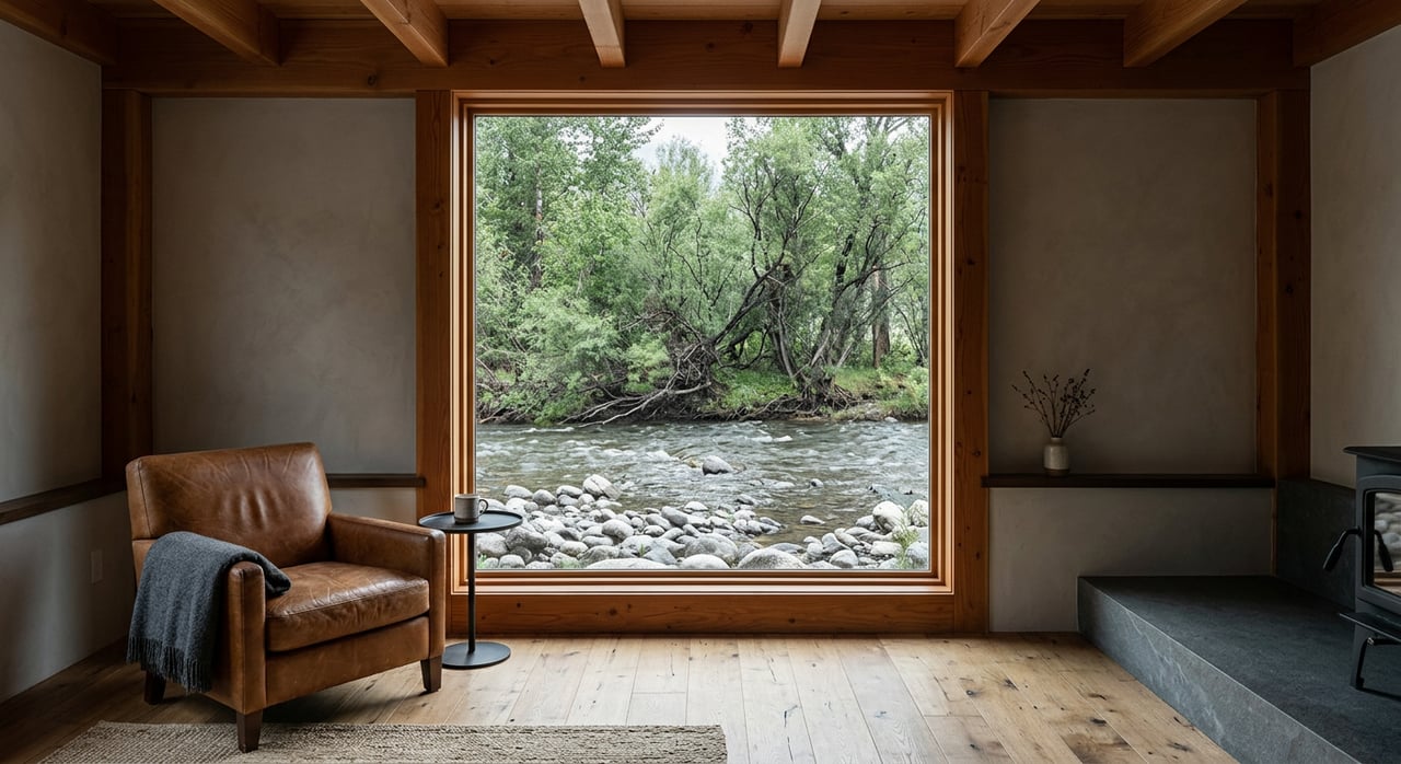
Valley‑floor riverfront parcels
Riverfront homes and small ranches put the Bitterroot at your doorstep. Expect direct access for fishing or launching small watercraft, and a true on‑the‑water feel. These parcels often sit in or near mapped flood hazard areas, so floodplain research and insurance planning are part of a smart purchase.
High‑bench and view acreage
Higher benches above the valley floor offer broad Bitterroot Valley views and more separation from mapped flood hazards. If you value privacy, big‑sky vistas, and room to spread out while staying near the river corridor, this category is worth a close look.
Rural acreage with irrigation
If you want space for a hobby farm or horses, rural parcels with ditch infrastructure and water rights may fit. These properties come with paperwork and operating considerations, from seasonal delivery to right seniority. Plan to gather and review the full record set during due diligence.
What to know before you buy
Here is a practical checklist to guide your conversations and document review.
- Floodplain status and permits. Ask whether the parcel lies inside a FEMA or county regulated flood hazard area and check for any floodplain permits or recorded work. The state’s Bitterroot River summary outlines the mapped floodplain approach and background. Use county resources to confirm parcel specifics.
- River access, easements, and the high‑water mark. Montana Stream Access Law allows the public to use riverbeds for recreation up to the ordinary high‑water mark when entered legally. How you and neighbors reach the water across private land is separate. Confirm any recorded riparian easements and access routes in the title record. Review the official Stream Access Law brochure for definitions and examples.
- Septic and well suitability. In floodplains or areas with shallow groundwater, septic design can be more complex. For existing systems, confirm permits, locations, and well logs. Start with Ravalli County’s sanitation and subdivision materials to understand the review framework. See the county’s sanitation guidance packet.
- Water rights and irrigation. If irrigation or surface water shapes the property’s use, get copies of ditch agreements and water‑right records, including priority and delivery season. State statute governs water rights and their administration. Begin with Montana’s water rights code reference.
- Conservation lands and refuge adjacency. Parcels near conservation easements or the wildlife refuge can offer lasting open views and a quieter backdrop. They may also come with use limitations or management considerations. Ask for any recorded encumbrances and talk with the relevant agency staff if needed.
- Access logistics. On private riverfront, driveway, footpath, or shared community access details should be confirmed in writing. Make sure what you intend to do matches recorded rights.
Community and access
Stevensville has a small‑town feel with a strong civic culture. Town parks and local calendars support an outdoors‑forward lifestyle, and volunteer groups often help maintain trails and host events. For broader services, Hamilton is a short drive south, and Missoula is typically 25 to 35 minutes to the north, depending on route and conditions. That balance between quiet river town and regional access is a key part of the appeal.
Start your search with a local guide
Buying near the Bitterroot is part lifestyle choice, part technical due diligence. You deserve both: local insight on the day‑to‑day and careful guidance through floodplain, access, and water‑right questions. If you are ready to explore Stevensville river living, connect with Blayne Larson for straight answers and tailored options. Schedule a free consultation to get started.
FAQs
Can you fish from your private riverfront in Stevensville?
- Yes, with a valid fishing license if you are 12 or older, and subject to Montana Stream Access Law up to the ordinary high‑water mark. Confirm any private easements that govern how you reach the water across your land.
How public is the Bitterroot River shoreline near Stevensville?
- The riverbed is public for recreation up to the ordinary high‑water mark when you enter legally. Land above that line is private unless an easement or access point says otherwise. Check recorded title documents.
When is floating the Bitterroot safe for beginners around town?
- Spring runoff brings fast, cold water that can be hazardous. Late summer can be too shallow in dry years. Always check flows, scout your section, and wear a life jacket.
What should you check before buying riverfront property in Ravalli County?
- Floodplain mapping, any floodplain permits, septic and well records, water‑right details, and recorded access or riparian easements. Ask your agent to assemble and review these documents early.
Are there year‑round outdoor options if you are not an angler?
- Yes. The town’s parks, the River Park trail, and nearby refuge trails offer walking, birdwatching, and seasonal wildlife viewing. You can enjoy the river corridor without getting on the water.